 Retford Retford
St Saviour
Archaeology
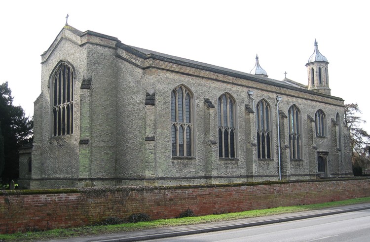
St Saviour’s church was designed and built as a complete entity. There
have been very few changes to its external appearance since construction in
1827-29.
The architraves around the windows and doors are of finely crystalline, dolomitic
limestone, probably from Steetley quarry. Above the south door, and above the
window fitted in place of the north door, the mouldings are beginning to crumble
due to weathering.
The roof is of slates, which were renewed in 1970, using second hand Welsh
slates. The gutters are on the roof side of a low parapet wall, along the north
and south sides; each gutter has two drains into separate hopper heads and
fall pipes. Each of the four ground level gulleys drains via underground pipes
into a local ditch at the side of the A620 main road.
In June 1902, a flagstaff was fitted at the apex of the West end of the church
roof. At some time this has been removed but the internal fittings for it still
remain in position inside the building.
The original flooring was of flagstones. Due to wear those in the centre aisle
were replaced in 1914 by oak blocks; the flagstones of the side aisles were
similarly replaced in 1915. The wood blocked areas were edged with small white
tiles about one inch square, with black tiles of the same size forming a geometric
pattern.
The floor area around the altar is also tiled, using tiles about 10cm square,
four of the tiles each have the emblem of one of the four gospel writers in
a contrasting colour, all of these tiles were carpeted over in the year 2001
re-ordering.
A concrete ramp to give easy access to the church via the south door for
disabled people and wheelchairs was made in 1989.
During the 2001 refurbishment, a paved area at the west end of the church,
which still had stone slabs in good condition, was retained, thus giving a
pleasing contrast between old and new.
Geologically, the church appears to be built on a rather sandy soil, which
is underlaid by a clay pan. Although this has not been tested by excavation,
there is drainage of water from the cellar of the old vicarage (to the east
of the church) the water passing under the church and rising through the floor
of the chamber housing the heater unit, which is about ten feet below ground
level. The water leaves the heater chamber via a floor level pipe with unknown
destination. This water flow usually occurs only after several days of rainfall.
It is not known how far down the foundation of the walls and pillars extend,
there is occasional evidence of slight water seepage at just above floor level,
in walls and pillars. There is no evidence of any subsidence in the walls or
floor.
When the church was first built there was not enough money available to build
a boundary wall along Welham Road, subsequently such a wall was built, but
there do not appear to be any records as to when this was done. What is known
is that the present boundary wall was built some time after 1853, but before
1886, as the wall carries an Ordnance Survey benchmark on its outer face which
is shown on the large scale Ordnance Survey map of the area, dated 1886, but
not on a similar map dated 1853.
|