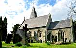
 Gonalston Gonalston
St Laurence
History
The village of Gonalston is listed in the 1086 Domesday Book as Gunnvestune.
By 1205 it was called Gonalvestune and by 1280 Gunolston. William Peveril and
Ralph of Limesy are listed as landowners. Erwin the priest is also listed as
a landowner, but there is no evidence that he actually lived or served the
village in a religious capacity. He also had lands in other parts of the county.
Parts of the church date from the Norman period, but possibly only the south
and north walls of the chancel. The windows set in those walls are attributed
to the late 13th Century, perhaps the result of a directive dated 1289 from
John Romaine, Archbishop of York ‘to make the church repaired’.
This would confirm that the building on the site was well established by that
date. At some unknown date the north aisle was added but in 1785 the eastern
part of it, which extended part way alongside the chancel forming a narrow
chapel, was demolished when Sir Phillip Monoux reduced the size of the church.
Most of the present church dates from 1853 when it was rebuilt by local architect
Thomas Chambers Hine.
The armourial insignia of the de-Heriz family (three hedgehogs - 13th Century)
can be seen in the upper part of a window tracery on the north aisle. The de-Heriz
family were Lords of the Manor and also patrons of the church from at least
that time until the family name died out in the 14th Century on the death of
the last male heir. The surviving female, Matilda de-Heriz, married Richard
de la Riviere. By the 18th Century the lordship and the advowson of the church
was in the hands of the Monoux family. The present Lords of the Manor, the
Francklins are direct descendants of the Monoux’s. However the advowdon
of the church has changed ownership on many occasions. It was the subject
of litigation in 1199 when the Archbishop of Rouen claimed ownership, stating
that he had been gifted the church by King John in 1191-1193 when the latter
was Earl of Mortain. Iv de Heriz successfully contested the claim and recovered
the church in 1200. In 1619 the advowson was sold by Lewis Monoux to Hugh Bagguley,
the then Rector of the church. During the first half of the 19th century the
ownership changed hands several times. The Francklin family are the current
patrons of the church.
On the east border of the parish is the village of Thurgarton which, until
the dissolution of the Monasteries, was the location of Thurgarton Priory,
founded in the late 12th Century by the black canons of the Augustinian
order. The order also owned much of the parish of Hoveringham, which forms
the southern boundary of Gonalston. Following the visitation of 1536 the priory
was dissolved in 1538. Although Gonalston was almost surrounded by the Priory
lands there seems to be little evidence of any religious or social interaction
between the Priors and the parish church. One document, which has survived,
states that an agreement was made in 1235 between Sir John de Heriz and the
Prior of Thurgarton allowing the Prior “pasture for 50 head of cattle
and 50 swine”. Thurgarton priory was used as a small Royalist garrison
during the English Civil war. Its main task then was to harass Parliamentary
troops on their way to attack the Royalist stronghold of Newark. The garrison
was eventually surrendered to Colonel Thornhaugh with little resistance.
In the reign of Henry III (1216-1272) William de Heriz founded a ‘Spital’ on
land now about half a mile along the A612 road to the south of the church.
No trace of this building now remains. A local farmhouse is however called
Spital farm, and it is said that masonry from the Spital is incorporated into
it. Joannes, daughter of John de Heriz, added a Chantry chapel to the Spital
in 1326. Throsby in 1797 described the building as being “a cold building
in poor condition with no glass in the windows”. He did not record whether
it was still in use and it is known to have been demolished in 1820, with the
altar slab from the chapel being placed in the church. Westmacott in 1848,
confirmed that there was at that time three old altar slabs with incised crosses
within St Laurence’s, but none are now visible. In the early 1930s
the Nottingham to Southwell Road (A612), which ran a winding route through
the village passing the church on its south side, was ‘straightened’ cutting
out the need for travellers or traffic to pass through. The new road cut through
the south side of the church burial ground isolating it from the former Spital
site and leaving the church on the north side of the new road. The Ordnance
Survey map of 1921 shows a footpath leading from the church southwards towards
the old Spital. This footpath is no longer evident in the church grounds but
on the opposite side of the new road there is a narrow road leading to the
village of Hoveringham.
In 1768 the Gonalston Enclosure Act allocated 155 acres of land to the church
in lieu of tithes. The village acreage in 1851 was recorded as 950, so it was
a sizeable award. The boundaries of the village have been changed several times
since then; from 1879 it is usually given as about 1330 acres, but the western
boundary with Lowdham has changed in the last sixty years
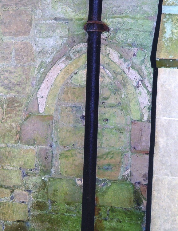
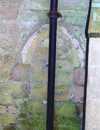 Remains
of a Remains
of a
piscina on the
external wall |
 Filled
arch in Filled
arch in
chancel wall |
The first major renovation work recorded at St Laurence’s
took place in 1787 when Sir Phillip Monoux carried out a ‘diminution’.
This involved demolishing
the part of the north aisle that extended alongside the chancel, which housed
a small chapel, and filling the open end with a new window.
A piscina originally inside the side chapel can be seen built into the exterior
face of the north wall along with the infilled arch from the chancel.
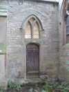
 Three
effigies stored Three
effigies stored
in a corner |
During
this building operation the three stone coffin covers with carved effigies
of the de-Heriz family were removed and thrown under the floor of the nave
where they remained until recovered by Richard Westmacott RA in 1848. Westmacott
wrote a graphic account of his work, detailing the search and recovery of the
effigies. He believed that the recovered effigies would be allocated a prominent
position within the rebuilt church. Today they are rather ignominiously stored
in the corner of the north aisle close to the chancel arch.
In 1851 the morning service on census Sunday was attended
by 23 people and the afternoon service by 54, from a population of only 100.
Edmund Footitt, the Rector, noted that “the few children there are attend
school in a neighbouring parish under an efficient master”.
Like many Anglican churches in the 19th century St Laurence’s
was subject to major renovation and rebuilding. The work was undertaken in
1853 directed by Nottingham architect Thomas Chambers Hine. The entire nave
was rebuilt including the north aisle and arcade; previously the bell tower
was a wooden structure attached to the west end of the church, housing just
two
bells. The new tower was not sited centrally but over
the northwest corner of the church and built in stone. Two new bells were added
to make a ring of four.
A rectory with spacious grounds was sited on the north side of the church
screening it from the village road. Pevsner dates it from 1785 and suggests
that evidence of an earlier dwelling is incorporated within it. It is built
of brick with stone decoration, and is now a privately owned residence aptly
named the Old Rectory
Access to the church is down a grassed track at the side of the rectory. There
is no hard surfaced vehicular access to the church. With the trees and vegetation
on the southern boundary of the churchyard, St Laurence’s is not
a very visible building, and many travellers along the both the A612 road and
the village road are probably unaware that it exists. This makes the churchyard
a very quiet retreat, surprisingly undisturbed by traffic noise or passers
by.
From the early part of the 19th Century the population of Gonalston
was always less than 140 people. In 1851 it was just 100, in 1901 it was 128
and in 1911 was 113. In 1912 the church had 26 children on the Sunday School
roll, and in the twelve months to September of that years there had been five
baptisms and four confirmations. In 1921 the population peaked at
134. It had again fallen to only 100 in 2001. Given these figures it is perhaps
not surprising that in the 1930s the parish of St Laurence’s Gonalston
was united with that of its larger neighbour Epperstone. The incumbent at the
time of the merger chose to reside in the latter village.
| 


 Remains
of a
Remains
of a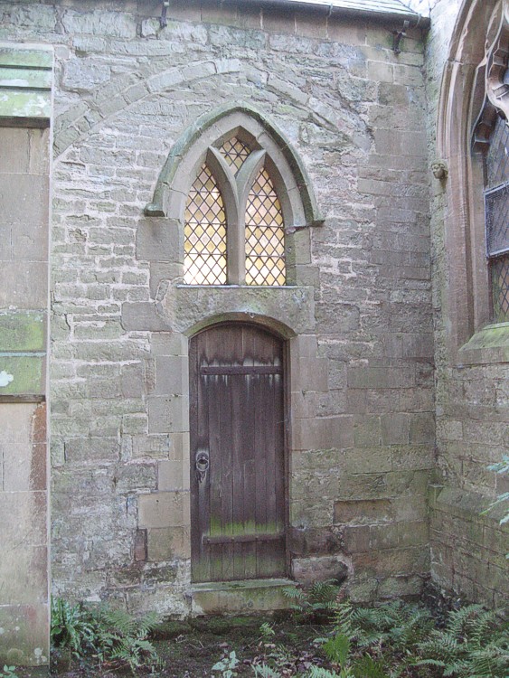 Filled
arch in
Filled
arch in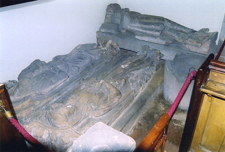 Three
effigies stored
Three
effigies stored


